「Plugins ogr converter」の版間の差分
提供: OSGeo.JP Wiki
(ページの作成: <H2> OGR Converter Plugin </H2> <P> The OGR Layer Converter plugin adds the ability to convert vector data from one OGR-supported vector format to another. The plugin is very s…) |
(内部リンク調整) |
||
| (同じ利用者による、間の1版が非表示) | |||
| 行1: | 行1: | ||
| − | + | === OGR Converter Plugin === | |
| − | OGR Converter Plugin | + | <span id='ogr_converter'></span> <!-- dummy --> |
| − | </ | + | |
| − | |||
The OGR Layer Converter plugin adds the ability to convert vector data from one OGR-supported | The OGR Layer Converter plugin adds the ability to convert vector data from one OGR-supported | ||
| − | vector format to another. | + | vector format to another.<ref>Supported formats may vary according to the installed |
| + | GDAL/OGR package.</ref> | ||
The plugin is very simple to run, and only requires a few parameters to be | The plugin is very simple to run, and only requires a few parameters to be | ||
specified before running: | specified before running: | ||
| − | < | + | <ul> |
| + | <li>'''Source Format/Datset/Layer''': Enter OGR format and path to the vector file to be converted | ||
| + | <li>'''Target Format/Datset/Layer''': Enter OGR format and path to the vector output file | ||
| + | </ul> | ||
| − | < | + | <table align='center'> |
| − | < | + | <caption>'''図 59:''' OGR Layer Converter Plugin {{Template:Nix}}</caption> |
| − | < | + | <tr><td><span id='fig:ogr_converter_dialog'></span> |
| − | < | + | [[File:ogr_converter_dialog.png|340px]]</td></tr></table> |
| − | </ | + | |
| − | </ | + | |
| − | + | ===== Using the Plugin ===== | |
| − | < | + | <ol> |
| − | < | + | <li>Start QGIS, load the OGR converter plugin in the Plugin Manager (see Section |
| − | + | [[sec:load_core_plugin]]) and click on the {{Template:ToolBtnTwo|ogr_converter|OGR Layer Converter}} | |
| − | OGR Layer Converter | + | icon which appears in the QGIS toolbar menu. The OGR Layer Converter plugin dialog appears as shown in Figure [[#fig:ogrconverter_dialog|59]]. |
| − | < | + | <li>Select the OGR-supported format (e.g., {{Template:SelectString|ESRI Shapefile|...}}) and the path to the vector input file (e.g., {{Template:FileName|alaska.shp}}) in the Source area. |
| − | < | + | <li>Select the OGR-supported format (e.g., {{Template:SelectString|GML|...}}) and define a path and the vector output filename (e.g., {{Template:FileName|alaska.gml}}) in the Target area. |
| − | < | + | <li>Click {{Template:Button|Ok}}. |
| − | + | </ol> | |
| − | + | ||
| − | + | ---- | |
| − | + | <references/> | |
| − | + | ||
| − | + | ||
| − | + | ||
| − | + | ||
| − | + | ||
| − | + | ||
| − | + | ||
| − | + | ||
| − | + | ||
| − | + | ||
| − | + | ||
| − | + | ||
| − | + | ||
| − | </ | + | |
| − | + | ||
| − | + | ||
| − | + | ||
| − | + | ||
| − | + | ||
2009年10月6日 (火) 02:24時点における最新版
OGR Converter Plugin
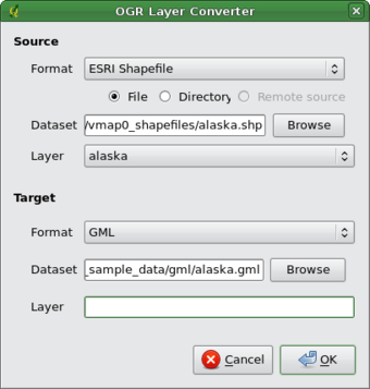
The OGR Layer Converter plugin adds the ability to convert vector data from one OGR-supported vector format to another.<ref>Supported formats may vary according to the installed GDAL/OGR package.</ref> The plugin is very simple to run, and only requires a few parameters to be specified before running:
- Source Format/Datset/Layer: Enter OGR format and path to the vector file to be converted
- Target Format/Datset/Layer: Enter OGR format and path to the vector output file
 |
Using the Plugin
- Start QGIS, load the OGR converter plugin in the Plugin Manager (see Section
sec:load_core_plugin) and click on the
 OGR Layer Converter
icon which appears in the QGIS toolbar menu. The OGR Layer Converter plugin dialog appears as shown in Figure 59.
- Select the OGR-supported format (e.g., ESRI Shapefile ...
 ) and the path to the vector input file (e.g., alaska.shp) in the Source area.
- Select the OGR-supported format (e.g., GML ...
 ) and define a path and the vector output filename (e.g., alaska.gml) in the Target area.
- Click Ok.
<references/>